Echuca has three main rivers either bordering or near the township; the Murray River to
the north, the Campaspe River to the west and the Goulburn River which joins the Murray
north east about 15 kilometres upstream towards Barmah.
These river systems make Echuca and its surrounding areas prone to flooding with major
floods affecting people, animals and property since flood records began in 1867.
Historically, there have been more than 16 significant floods
since 1867 in the Campaspe Shire, most recently there were four floods which occurred
between September 2010 and February 2011.
Flooding can occur on one river or be caused by a combination of all three rivers.
Historically the worst floods are from a combination of the flooded rivers rather than just
one, as well its surrounding areas are vulnerable to cross country overflows of water
because of the flat nature of the local countryside.
Some of the town’s levees were constructed at Echuca in 1956 and again between 1989
and 1992 to provide some protection to the town’s central business district and the water
treatment plant from most large floods. However, no levee is flood proof and parts of the
town with and without levees are still prone to flooding.
Even if property is not impacted by floodwater, it may be affected indirectly by flooding as
some roads will be closed and power, sewerage, water supply and telephone and data
services may be disrupted
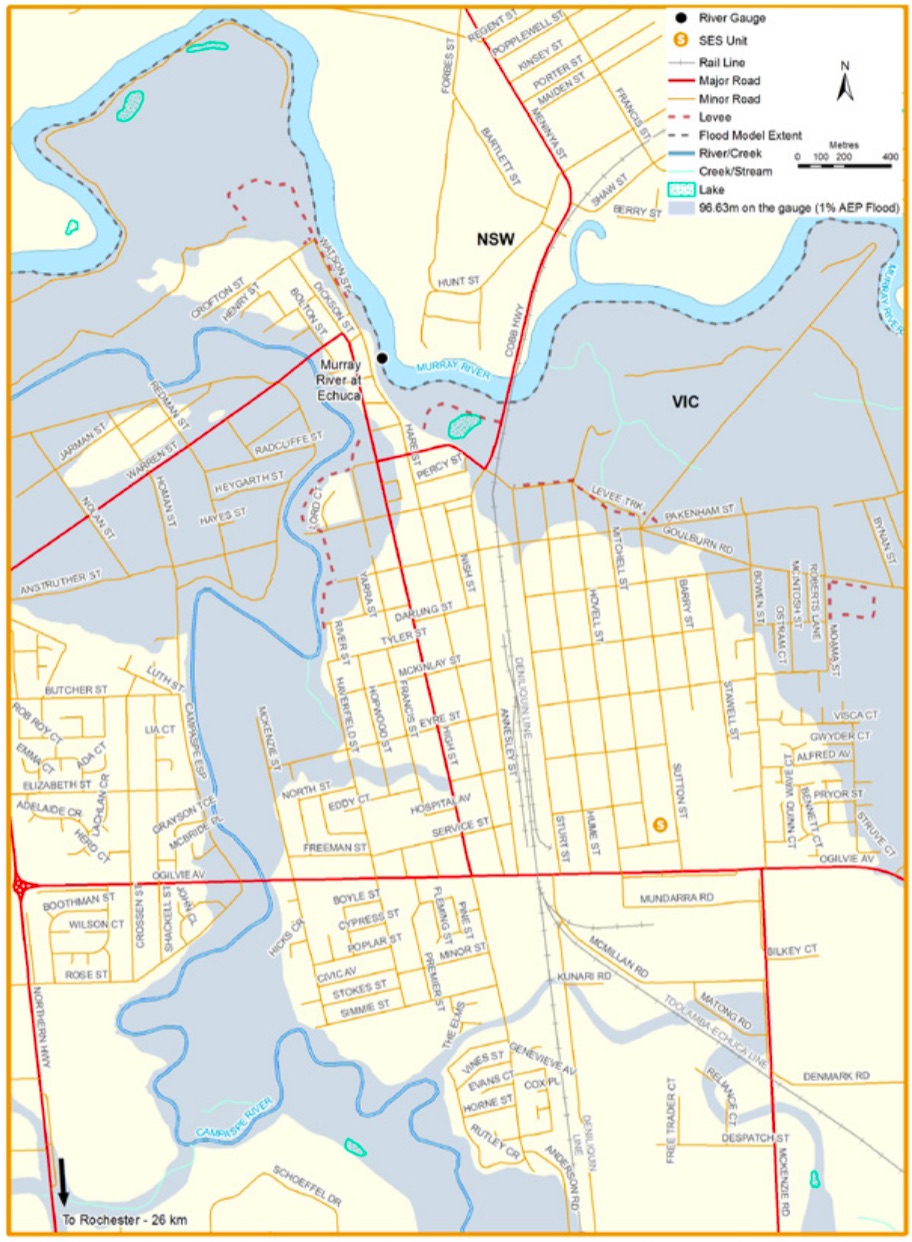
Click on the map below to see how the region was impacted by the floods of 1993, 2011, 2016
and 2022.
While no two floods are the same, the following table can give you an indication of what
you can expect at certain heights at the Wharf.
The Echuca wharf gauge is measured based on the Australian Height Datum (AHD) which assumes the sea level is 0 metres.
96.20m 1870 flood- Highest recorded flood. The worst flood to affect Echuca occurred in 1870 when extensive parts of Echuca Moama and its surrounding rural areas were flooded
95.00m Floodwater begins to wet properties in the area bounded by Ogilvie Avenue, Bowen and Snowden St.
94.90m Properties at the river end of Martin Street along with properties on the west side of the Ogilvie Avenue bridge would start getting wet.
94.77m October 1993 flood
94.75m February 1973 flood
94.70m Some flooding of Haverfield and Eyre streets with water encroaching on the rear of properties in Rutley Crescent. Water would also encroach into properties at the river end of streets in the area to the west of Dickson Street and north of Cohuna – Echuca Road
94.60m There would be flooding into McBride Place from the Campaspe River and water over Etona Avenue and Mary Anne Road is likely to be impassable from Ogilvie Avenue to the Murray River
94.52m May 1974 flood
94.40m Major Flood level
94.30m At this level, there would be areas of deep flooding in parts of Echuca to the West of the Campaspe River. It’s likely Hansen Street and the river end of Jarman Street would be surrounded by water and all other streets West of the Campaspe would be flooded. The Campaspe River end of Martin Street would be flooding, as well as the Southern Cross Drain near the intersection of Pakenham and Bynan Streets with Mary Anne Road getting wet .
94.20m October 1992 flood
93.90m Moderate Flood level
93.60m Flooding becomes established in some parts of Echuca to the West of the Campaspe River and the lower end of the Campaspe Esplanade would become impassable.
93.50m Minor Flood level
92.85m January 2011 flood - Campaspe River caused flooding in parts of Echuca to the West of the Campaspe River and additional water flowed into the Murray River.
Courtesy SES Vic
92.825 AHD 11/10/22
93.568 16/10/2022 -Moderate Flood Level
94.692 22/10/2022
94.936 25/10/2022 -Major Flood Level
94.947 26/10/2022
94.946 28/10/2022
93.471 06/10/2022 -Minor Flood Level